From dramatic mountain passes and volcanic peaks to coastal trails and historic pilgrimages, Spain is a paradise for walking and hiking enthusiasts with no shortage of unforgettable day hikes and multi-day treks.
The headline walking experience is the Camino de Santiago, Europe’s most iconic pilgrimage route. This isn’t included here as, in addition to the original, there are starting points ranging from Portugal to France, so I am working on a thorough stand-alone Camino de Santiago guide.
Here, however, are some of the best walking and hiking routes in Spain, ranging from the Picos de Europa to the Sierra de Nevada, including hikes on Spain’s Balearic and Canary Islands.
*If you’re basing yourself in Madrid or plan on visiting, you can also find several hikes close to the capital in my Madrid guide.
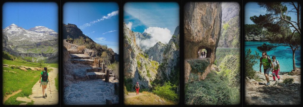
Ruta del Cares
📍 Poncebos (Asturias) ↔ Caín (León), Picos de Europa
Often described as one of the most beautiful walks in northern Spain, the Ruta del Cares follows a narrow path carved directly into the rock walls of the Picos de Europa. The trail runs high above the Río Cares, threading its way through tunnels, sheer limestone cliffs, and dramatic drop-offs.
Despite its wild appearance, the route is relatively accessible and attracts walkers from all over Spain, especially on clear summer days when the gorge glows different shades of green. There are a few different places you can start, but Poncebos to Caín is the most common.
Distance: 12 km one way
Difficulty: Moderate (exposure, not technical)
Parking: Paid parking in Poncebos, very limited in Caín
Cost: Free
Best season: May through to October
Weather notes: Avoid after heavy rain as there is a rockfall risk
Important tip! Most hikers go from Poncebos to Caín and return by taxi. This is the best way given parking and other factors.

You can load the route on Komoot here.
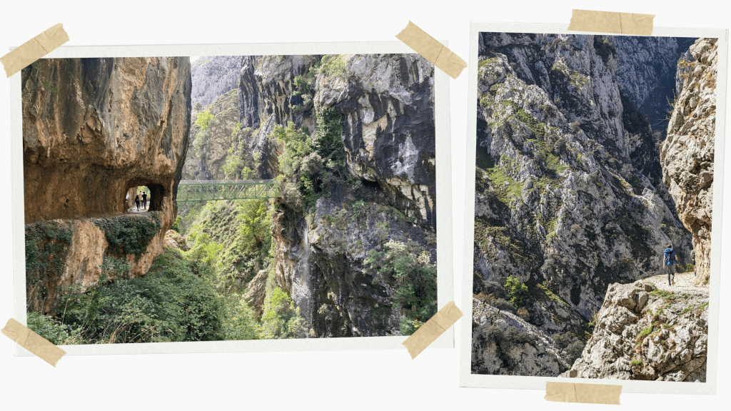
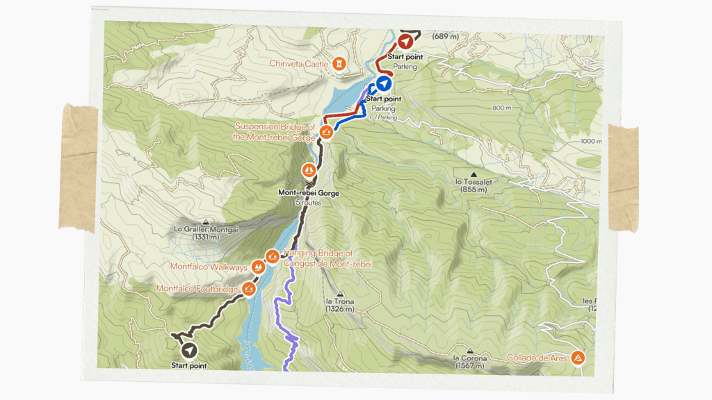
Congost de Mont Rebei
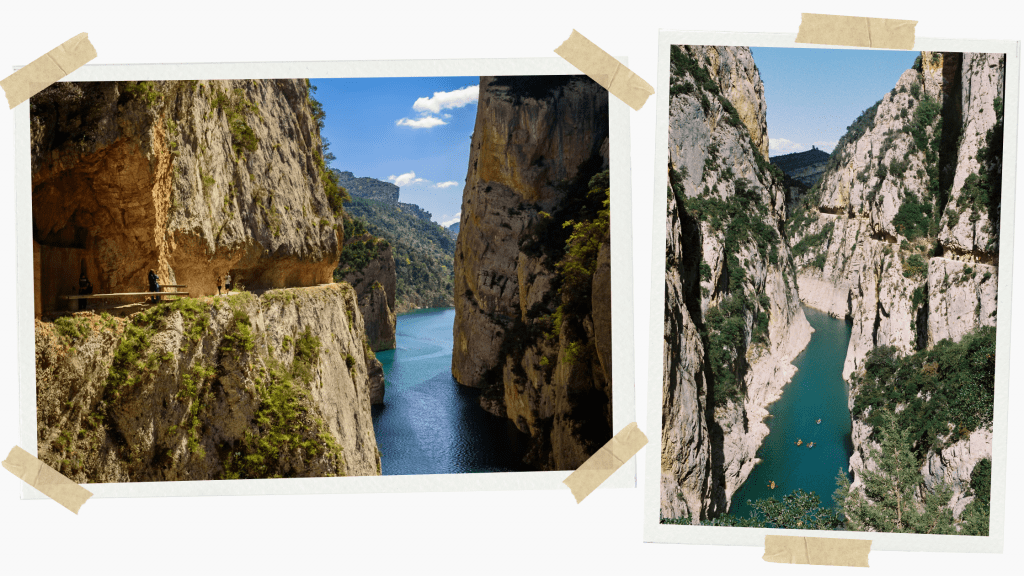
📍 Aragón / Catalunya border
This spectacular canyon hike features suspension bridges and a route cut into vertical cliffs, taking you alongside striking turquoise water. Despite the drama, it’s a well-maintained route and surprisingly peaceful once you move away from the access points. At the trailhead, a small shop with picnic benches sells snacks, cold drinks, and artisan beers perfect for a post-hike drink to admire the views.
You can also kayak through the gorge and enjoy a completely different perspective from below if you’re staying nearby and haven’t had enough of this stunning gorge on foot!
Distance: 12 km round trip
Difficulty: Moderate (heights, narrow paths)
Parking: La Masieta or Montfalcó (paid in high season)
Cost: Free trail but the parking is usually €5–8
Best season: Spring & Autumn
Weather notes: Extremely hot in summer
Important tip! The Montfalcó access point includes a bridge and then a steep section up to the wooden stairs. This section is a little gruelling, especially coming at the end of the hike before you turn back. The terrain doesn’t have flat, clean footing but the views from the top of the stairs are spectacular. Some people wait here as others head up and come back down.
You can load the route on Komoot here.
El Caminito del Rey
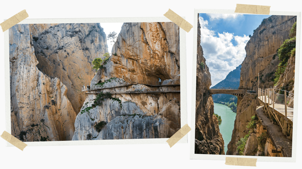
📍 Near Málaga, Andalucía
A cliffside boardwalk above a deep gorge, the Caminito del Rey was once infamous as being one of the most dangerous walks in the world but has now been completely restored and transformed into a safe, controlled, and unforgettable experience.
The route follows a narrow boardwalk bolted into vertical canyon walls high above the Guadalhorce Gorge. While the danger is gone, the sense of height and scale remains, making it thrilling without being physically demanding.
This is less a mountain hike and more a dramatic linear walk, ideal if you want big scenery without a long or strenuous day.
Distance: 7.7 km (one way)
Difficulty: Easy–moderate
Parking: Official lots at Ardales or El Chorro
Cost: It is €10–18 for access tickets, prices depend on whether you want a guide or not
Best season: Year-round but fantastic in winter
Weather notes: Closes in high wind or storms
Important tip! Tickets sell out weeks ahead in peak months, so make sure you plan in advance.
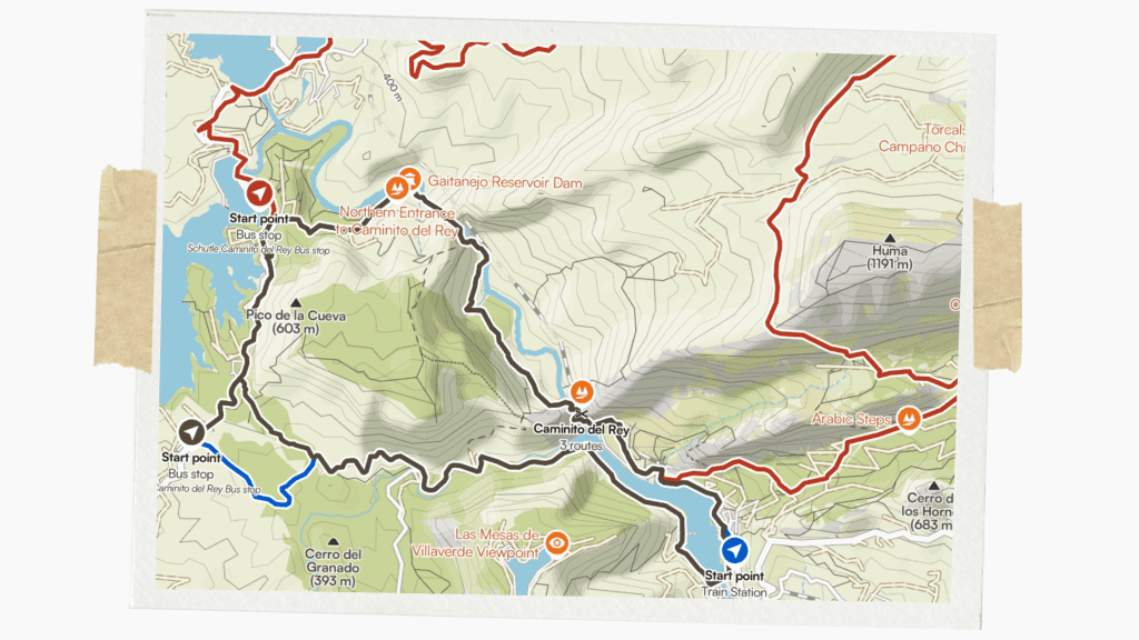
The traditional popular Caminito del Rey route is a one-way system with clear, designated start and end points. There are, however, other hikes around the area which can be loaded on Komoot here.
Ordesa Valley

📍 Ordesa y Monte Perdido National Park, Aragón
This is one of the classic hikes of the Spanish Pyrenees and a perfect introduction to high-mountain landscapes. There are many trails gradually climbing through lush beech forests, open meadows, and cascading waterfalls. The best route to do is one that takes you beneath the particularly special Cola de Caballo waterfall at the end of the valley.
This setting beneath Monte Perdido feels vast and distinctly alpine, especially in early summer when snow still crowns the peaks.
Distance: 18 km round trip
Difficulty: Moderate
Parking: Pradera de Ordesa
Cost: Free
Best season: June–October
Weather notes: Snow lingers into early summer, so prepare for that
Important tip! Start early to avoid crowds and afternoon storms.
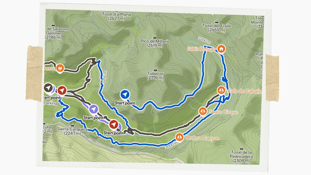
As mentioned, there are various routes in the Ordesa y Monte Perdido National Park which can be loaded on Komoot here. I recommend the first: “Cola de Caballo via the Soaso Steps from the Ordesa Meadow”.
Pico del Teide hike
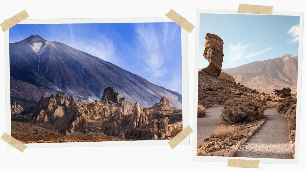
📍Teide National Park, Tenerife, Canary Islands
Parque Nacional del Teide is one of the 12 Treasures of Spain and home to Spain’s highest peak, the 3,700 metre high Pico del Teide. I have a detailed breakdown of all the routes available in my Tenerife guide. These range from challenging trails summiting the peak itself (which requires an obtainable permit) to easy routes through the surroundings designed for families.
There are a grand total of 41 hiking trails in the park, starting at different points but all offering surreal walks through volcanic landscapes, often above the clouds. Here is information for the most iconic trail summiting the peak, which can be made shorter by getting a cable car to La Rambleta. Head to my Tenerife guide for other routes.
Distance: 8.3km one-way from Montaña Blanca to La Rambleta (Trail 7) and then a 1.5km stretch on the Telesforo Bravo trail (Trail 10) from La Rambleta to the summit of 3,718 m
Difficulty: Moderate-hard (altitude)
Parking: Large free car parks at trailheads
Cost: Free
Best season: Year-round
Weather notes: Very cold at the summit even in summer
Important tip! The section from La Rambleta to the summit is a steep, exposed, altitude-challenging section which requires a permit, easily obtained via the official website and should be applied for weeks ahead of time.
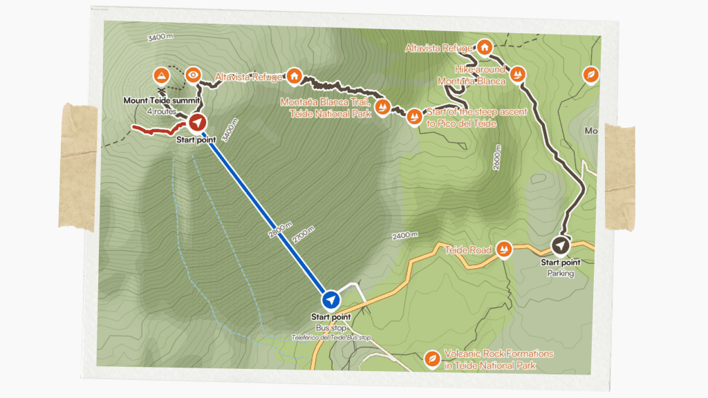
You can load the Tedie routes on Komoot here.
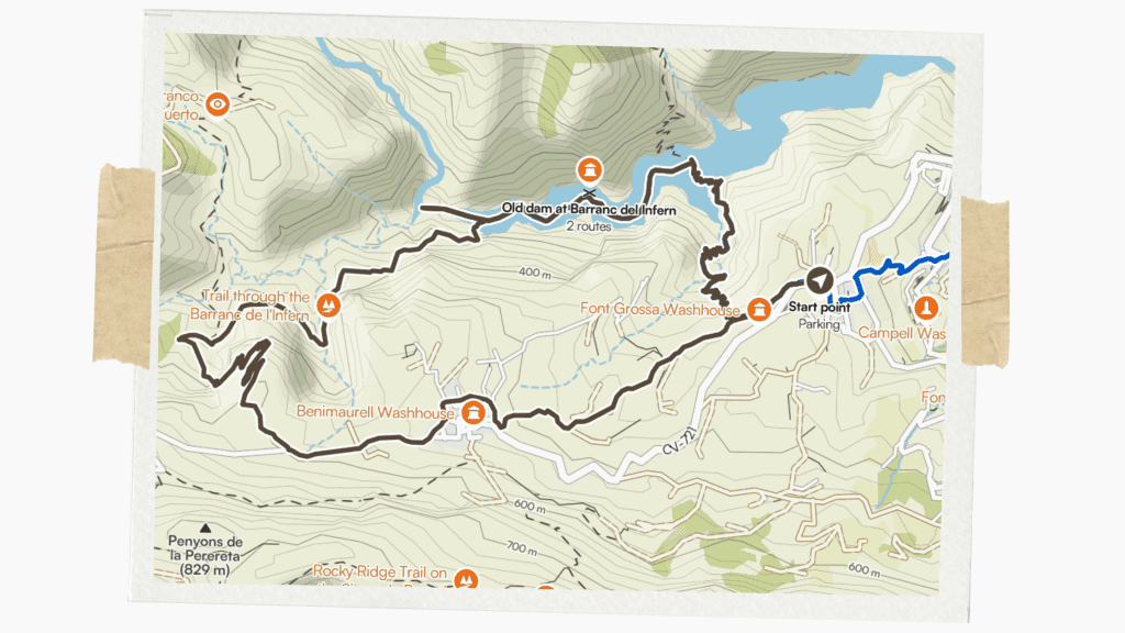
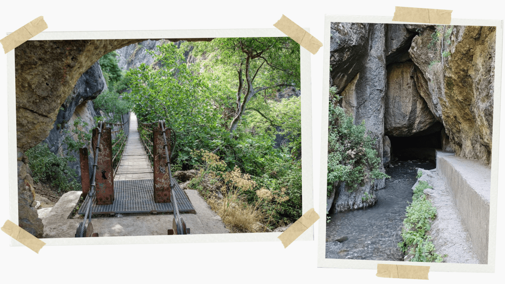
Barranco del Infierno Old Dam hike
📍 Vall de Laguar, Alicante, Comunitat Valenciana
Despite its dramatic name (Barranc de l’Infern in Valencian, which translates to “Hell’s Gorge”), this hike is one of the most enjoyable controlled walks in eastern Spain. Stone steps, ladders, and handrails guide you through a narrow ravine filled with vegetation, waterfalls, and birdsong via an old dam. Because it’s a protected natural area with limited access, the trail feels calm and well-preserved, making it ideal for a half-day outing without crowds.
Distance: 6.5 km round trip
Difficulty: Moderate
Parking: Official parking area at the entrance
Cost: €8 (reservation required)
Best season: Spring
Weather notes: Closes after heavy rain
Important tip! Daily visitor numbers are capped so make sure you reserve in advance.
You can load the Barranco del Infierno route on Komoot here.
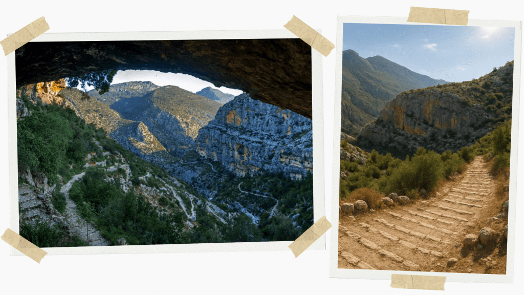
Ruta de los Cahorros
📍 Monachil near Granada, Andalucía
Just outside Granada, this gorge hike combines hanging bridges, narrow canyon sections, caves, and riverside paths into a compact but memorable loop. It’s more adventurous than it is long, making it perfect if you want a bit of excitement without committing to a full mountain day.
Distance: 6–8 km loop
Difficulty: Moderate
Parking: Street parking in Monachil
Cost: Free
Best season: Spring and autumn
Weather notes: Slippery after rain
Important tip! It can be crowded on weekends with all the people who come from Granada, so it can be more peaceful to go on weekdays if possible.

You can load the Ruta de los Cahorros hike on Komoot here.
Flysch Route
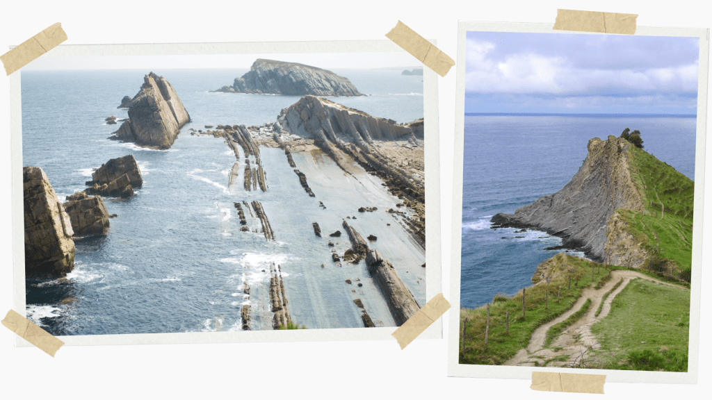
📍 Zumaia, País Vasco
This coastal walk is as much a journey through time as it is a hike. The exposed rock layers (known as flysch) record millions of years of geological history, visible in dramatic striped cliffs along the shoreline. The route links Zumaia with nearby coastal viewpoints and is especially striking when the sea is calm and the light is low.
Fans of Game of Thrones may also recognise this stretch of coastline, as nearby locations along the Basque coast were used as filming sites for Dragonstone. On that topic, one of my favourite spots, San Juan de Gaztelugatxe, can be found slightly further along the coast. This islet is home to a 10th-century hermitage reached by an old bridge and 241 steps. It was used as the site of Dragonstone itself.
Distance: 6 km one way
Difficulty: Easy–moderate
Parking: Town parking in Zumaia
Cost: Free (guided geology tours optional)
Best season: Spring and summer
Weather notes: Check tide times
Important tip! Low tide reveals the best formations, so if you can time it well, it can be even more spectacular.
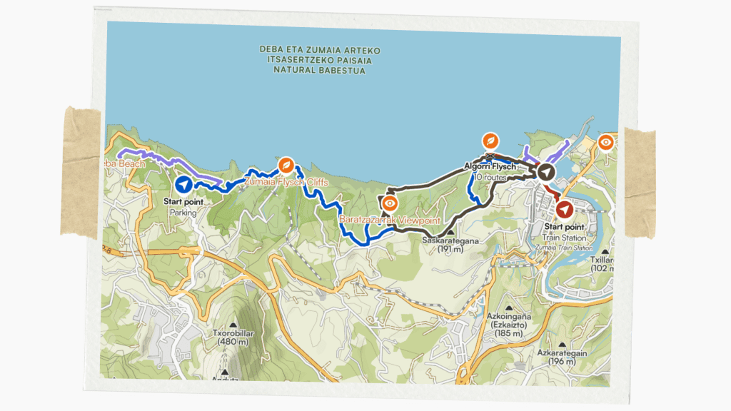
You can load various Flysch routes on Komoot here.
Senda del Oso
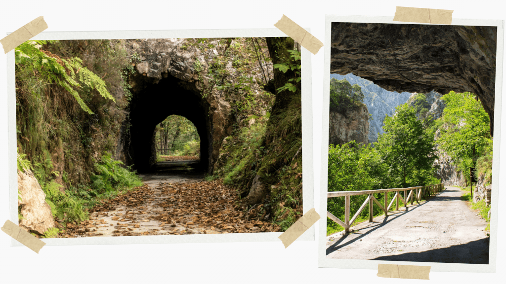
📍 Near Oviedo, Asturias
Built along a former mining railway, this gentle greenway winds through wooded valleys, tunnels, and river crossings in rural Asturias. With minimal elevation change and a wide, well-maintained surface, it’s ideal for relaxed walking, cycling, or family outings.
Distance: 22 km (sections possible)
Difficulty: Easy
Parking: Multiple village access points
Cost: Free
Best season: Year-round
Weather notes: Frequent rain
Important tip! Bike rentals are also widely available if you would like to explore this route on two wheels.

You can load the Senda del Oso route on Komoot here.
Balearic Islands multi-day hikes
Menorca’s Camí de Cavalls
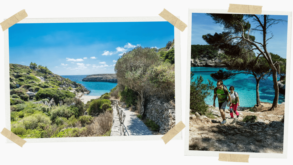
📍Menorca, Balearic Islands
Encircling the entire island, the Camí de Cavalls is an ancient coastal path once used for defence and patrols. Today it offers one of the most varied walking experiences in Spain, passing beaches, wetlands, cliffs, pine forests, and farmland. You don’t need to commit to the full loop as many sections work beautifully as half-day or single-day hikes.
Distance: The whole path is 185 km total, but you can choose stages
Difficulty: Easy to moderate
Parking: Trailheads all around the island
Cost: Free
Best season: Spring & autumn
Weather notes: Wind exposure on the north coast
Important tip! Many sections are ideal half-day hikes and can be best enjoyed by tying them with a visit to one of Menorca’s many incredible beaches. Head to my Menorca guide for more info if you’re thinking of doing one of these walks.
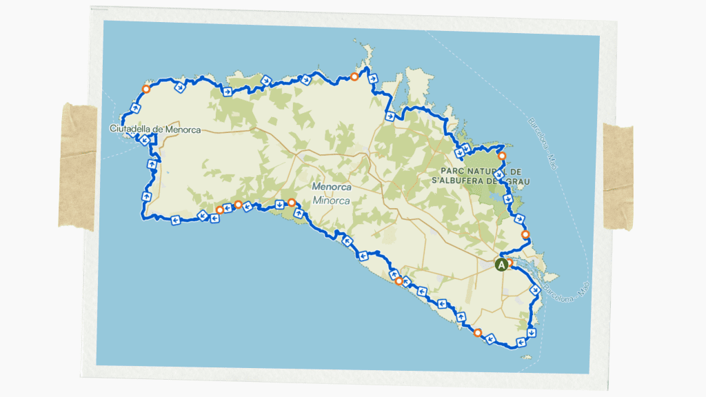
You can load various routes of the Camí de Cavalls on Komoot here.
Mallorca’s Tramuntana Ruta GR221
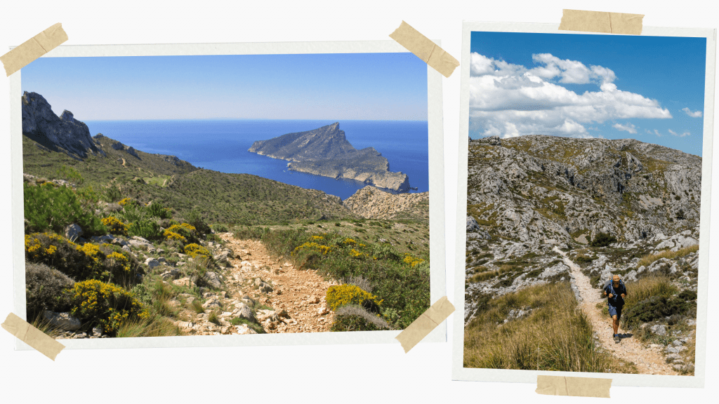
📍 Mallorca, Balearic Islands
Menorca’s bigger sister, the neighbouring island of Mallorca, is also home to a stunning long-distance route through the Serra de Tramuntana mountain range. This is an outstanding route for serious hikers and can be split into routes from refuge to refuge (refugio).
The GR221 showcases a very different side of Mallorca from what most people know, linking historic villages, dry-stone terraces, monasteries, and high ridgelines with sweeping Mediterranean views. It’s demanding in places but deeply rewarding, especially when using the island’s mountain refuges.
Distance: 150 km total
Difficulty: Moderate-hard
Parking: Village access points
Cost: Free but if you’re serious about doing a large portion of it the refugios will cost extra
Best season: March-May and October-November
Weather notes: Heat is brutal in summer
Important tip! Book mountain refuges well in advance as they can book up.

You can load various routes of the Tramuntana Ruta GR221 on Komoot here.